The purpose of the Digital Humanities project “ Mapping The Republic of Letters” is to help people understand the networks of correspondence, the social and physical networks of famous scholars who live before the industrial revolution through the development of sophisticated, interactive visualization tools. I will examine the case of Benjamin Franklin in this post.
The primarily use of visualizations in Franklin’s case enabled people to understand the nature of Franklin’s correspondence and correspondents network that was comprised between 1756-1763. The examination of visualization also provides people important information about Franklin. By  reading the “letters” spreadsheet on this web page, people can find out the month and particular locations of letters that Franklin received. The spreadsheet on the right shows the countries that Franklin received most of his letters from between 1757 and 1763. Franklin received nearly all his letters from two places: British America and England. This leads people to think about the timing of Franklin’s ascent into the ranks of the “cosmopolitan” on the world stage. In July 1757, Franklin arrived in London to represent Pennsylvania in its dealings with Britain. And the year of 1757 is the starting point for a groundbreaking investigation of Franklin in the world of ideas. Therefore, the information provided by the spreadsheet makes sense that Franklin received letters most from British America and England. On the other hand, the spreadsheet shows the process that Franklin was on his way to becoming a giant.
Similarly, by reading the “correspondents” spreadsheet, people can learn Franklin’s top correspondents in details such as their gender, county of birth and community association or professional group. People can even find out where do women rank in Franklin’s network—he wrote most of his letters to men.
Besides examining visualization can provide important information, the research team developed the approach to further defining terms “Cosmopolitanism”. It compares Franklin’s correspondence network with Voltaire’s to reveal the prospects and limits of “Cosmopolitanism”. The geom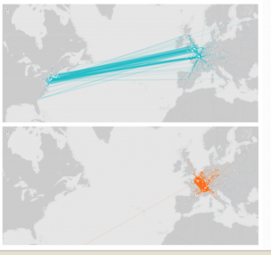 ap on the left shows Franklin’s network (top) and Voltaire’s (bottom).
Leave a Reply