As Bodenhammer mentions in his article, GIS is a seductive technology, a magic box capable of wondrous feats, and the images it constructs so effortlessly appeal to us in ways more subtle and more powerful than words can. In the past 2 weeks, we paid emphasis on how to use GIS to look for a new understanding this old journal in a spatial way. It’s amazing in the beginning to me since for the first time, I realized that we are capable of working on an old map. I can add footnotes on the walking route of Payne and add signs on the map. I can measure the average distance they walked per day by dividing the days from the length of the whole route through the measure function in GIS technology (474.5/31=15.3 miles). Since they walked all through the journey, 15 mile a day is not bad. And it’s back in 1747. The path they chose is like the Monocracy Path, one of the Indian Paths, and the Great Road. It did limit their traveling speed. What‘s more, they need to get the pass as soon as they arrived the new place and they need to talk with slave to preaching Moravian culture. All this physical elements affected their rate. What else I can do with the GIS technology is that I can add my own layer on the original map. With damaging the old map, we can overlap different map and look for their internal relationships. It’s what we can get through the written records. What mapping the travel route reveals about Payne and Froehlich’s journey is that how they choose this specific route, not that one. And since I’m really curious about this point, I created my own map story on this topic.
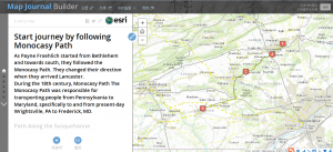
The process of learning how to use the GIS is really a fresh experience, but it gets even more magical when I create my own map story. When I was creating my own map story, I got a deeper understanding “Spaces are not simply the setting for historical action but are a significant product and determinant of change.” My map story talks about how they finally chose the route. The reason is quite complicated when we related Payne’s journal to Moravian Itinerant, Slaves, Plantation in Maryland and Virginia, Native American Paths, and other historical reasons. In this case, the function is marvelously significant when we create map layers. They started from Bethlehem in Monocracy Path. They changed direction when they arrived Lancaster. It’s because along the Susquehanna River live many Native Americans and there are also many colonial ferries. After they crossed the Susquehanna River and got into Maryland, wherever they stopped and lay at is never far from plantations. They started their journey from those concentrated areas of itinerancy and preaching in Pennsylvania and tried to bring Moravian culture to occasional areas of itinerancy and preaching in Maryland and Virginia.
Furthermore, as Bodenhammer said “deep maps…..are genuinely multimedia and multilayered”, we can use different composition of different maps to find new relationship between elements, like slaves, plantation and Moravian. As the history is complicated and different matters happened in different place at the same time. The multilayered maps give us a objective view what is going on. The following is the screenshot of the slides of my map story.
Leave a Reply